Neolithic navigation

celtiberian-II

Regular Member
Messages
78
Reaction score
30
Points
18
Location
Seville
Ethnic group
100% NW Castilian
Y-DNA haplogroup
J-L26
mtDNA haplogroup
H

The first Neolithic boats in the Mediterranean: The settlement of La Marmotta (Anguillara Sabazia, Lazio, Italy)​

Abstract​

Navigation in the Mediterranean in the Neolithic is studied here through the boats that were used, the degree of technical specialisation in their construction and, above all, their chronology. After a brief explanation of the exceptional site of La Marmotta, the characteristics and chronology of the five canoes found at the settlement and one of the nautical objects linked to Canoe 1 are discussed. This will allow a reflection on the capability of Neolithic societies for navigation owing to their high technological level. This technology was an essential part in the success of their expansion, bearing in mind that in a few millennia they occupied the whole Mediterranean from Cyprus to the Atlantic seaboard of the Iberian Peninsula.

 
This paper gives me the opportunity to express the idea that navigation is a human invention very very undervalued and, in my opinion, most important than the wheel. If someone is interested in this topic, it would be interesting to share some comments about this topic.

In the Neolithic, when farming communities began to spread around Europe, the Mediterranean was a space in which to travel and a means of communication. These communities reached coasts of the Iberian peninsula in about 5400 cal. BC. The Mediterranean Sea was used for travel, as boats allowed rapid movements of population, contacts and exchange of goods.

Sea voyages explain the occupation during this period of Cyprus, Corsica, Sicily and Greek islands like Icaria, Lemnos and Melos. Some canoes were small, but others were as large as those at Tybrind Vig (4300–4100 BC), 10m long. To have a reference, the caravel "La Niña" used by Columbus in his first voyage to America (about 5800 years later) was 15m long.

The first farming communities that entered in Europe travelling by sea were more successful than those that used a terrestrial route. A published paper demonstrated that the farming communities reached the British islands following an Atlantic route from the Iberian peninsula.

These achievements not only were possible thanks to the development of the vessel engineering but also to the acquisition of geographical, astronomical and navigation knowledge. We can say that the human brain was strongly shaped by navigation.

(to be continued)
 
(source: wikipedia)
The first alleged circumnavigation of the African continent attested to was made by Phoenician sailors, in an expedition commissioned by Egyptian pharaoh Necho II, c. 600 BC which took three years. A report of this expedition is provided by Herodotus (4.37). They sailed south, rounded the Cape heading west, made their way north to the Mediterranean, and then returned home. Herodotus himself is sceptical of the historicity of this feat; however, the reason he gives for disbelieving the story is the sailors' reported claim that when they sailed along the southern coast of Africa, they found the Sun stood to their right, in the north. Herodotus found this impossible to believe.

Some commentators took this circumstance as proof that the voyage is historical because of the spherical shape of the Earth. Navigation put in front this fact that propelled the human knowledge with revolutionary concepts.
 
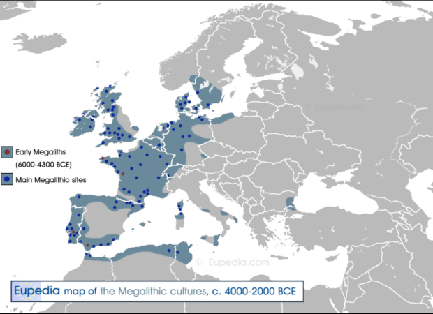
Farming communities were no simple. In fact, they can be associated not only to agricultural and navigation skills but also to the Megalithic culture (see, for example the Maciamo's thread https://www.eupedia.com/forum/threads/new-map-of-the-megalithic-cultures.40082/). Notice that the Early Megaliths (6000-4300 BCE) are located in the Iberian peninsula (south) and Brittany (France), in the Atlantic facade, to be specific. These monuments were constructed based on a very precise astronomical orientation.
1711232924350.png
 
Back
Top